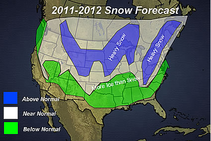
The basis of the forecast is on the prediction that a weak La Nina will be forming this fall and continuing through the winter. Last year, we had a strong La Nina with blocking over Greenland that lead to a very snowy winter across the Midwest and Northeast. While the pattern will be similar to last year, there will be changes in the pattern that will lead to the heavy snow areas shown on the map.
I am not convinced that blocking will be prevalent across Greenland this winter, however, with the trough axis predicted to be in the Midwest, that will lead to storms developing along the east coast and racing northeast. The cold will be back in the Appalachians, and that will lead to heavy snow in that area. The major cities will probably be fighting many mix precip storms with the snow lovers along the I-95 corridor pulling their hair over heavy snow versus ice and rain.
A storm track coming out of the Rockies will lead to storms moving through the western Great Lakes and a band of above-normal snowfall across the Midwest and western Great Lakes.
I also went with an above-normal snow area along the Front Range of the Rockies due mainly to arctic air masses coming down from Alberta.
By AccuWeather.com severe weather expert, Henry Margusity, offers the Meteorological Madness blog including detailed analysis of severe weather across the US.
For a complete article and map of the snowfall predictions click here