The 2018-19 winter season is in full swing, and Avalanche Canada has some big changes to help keep you safe in the backcountry.
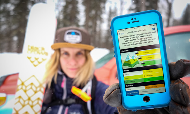
One of the things we’re most excited about this season is the introduction of our new Avalanche Canada app. This app replaces the older version, rather than updating it, so you’ll need to install the new one from your app store but the new download is well worth it. Our new app boasts some impressive improvements that make it easier than ever to access information while on the move.
The updated app features easier access to regional forecasts, avalanche advisories, and data from over 80 remote weather stations to help with your trip planning. It also provides an instant notification when Special Public Avalanche Warnings are issued, so you’ll never miss a warning again. When a warning is issued, you’ll see a banner on the app.
Another big improvement is the integration with the Mountain Information Network (MIN). The form on the new app is now easier to use than ever, allowing you to submit information about avalanches, weather and snowpack observations, as well as filing quick reports. The app also gives instant access to other MIN reports, meaning that up-to-the-minute information is always available to help plan for backcountry travel.
With the improvements to the app, we’re hoping to see an increase in MIN users. MIN reports are not only helpful to your trip planning but are vital to Avalanche Canada’s forecasters. Observations shared from the field provide our forecast team with valuable information in real time.
Get involved to win prizes
There’s even a weekly competition with prizes from our sponsors to encourage MIN submissions. Our South Rockies field team chooses a MIN winner each week in a random draw—great news for riders in that region! Our forecasters also select a winner each week, based on their favourite post. The best MIN is not the most technical post or written by the most knowledgeable author.
Weekly winners are often chosen for clearly outlining conditions and sharing good images. The best feature about the MIN is that it is really for everyone; you don’t need to be an expert to read the reports or share information.
Introducing the Dangerator
This winter we also introduced the Dangerator, a new tool to estimate avalanche danger in areas where there are no avalanche forecasts. The Dangerator’s two-step process presents the user with a short set of questions that requires gathering some local weather and snowpack data. We’ve designed the Dangerator to make it as easy as possible for the user to come up with an accurate estimation of their own danger rating.
The Dangerator is contained in a small booklet that explains each step of the process and how to gather the information required. We’ve also created a short video that helps explain how the tool works and includes some good sources for local weather information.
The Dangerator is an important step forward for us in providing more people with tools to make good choices in the backcountry. The estimated danger rating can then be used with the Avaluator and the online Trip Planner, decision-making aids that provide a structured approach to avalanche terrain management. Until now, these important tools could only be used in areas that receive a daily avalanche forecast.
Although the Dangerator cannot replace a daily forecast, it is the next best thing for those recreating in areas without them. This new tool is now provided to all Avalanche Skills Training (AST) students in regions without a forecast, along with training on how to use it. You can also get a Dangerator by emailing [email protected].
This has been an exciting season for us so far, and we hope yours is as well. Have a great, safe winter!