In the spring of 2016, Allan Bouchard of Grande Prairie, Alberta, became acutely aware of the large number of snowmobilers dying from exposure after losing their way or becoming stranded in the backcountry while out riding. “It made me sick to my stomach when I realized that some individuals were unaware they were only a couple hundred metres from a warm-up shelter that could have saved their lives,” Bouchard said. He knew there had to be a solution. A surveyor by trade, he set forth and created an app to facilitate backcountry safety and navigation.
The Never Lost Trails app, available on iTunes and Google Play, works with your existing cellphone (on airplane mode) even in areas where there is a lack of cellphone coverage. The app gives you the ability to know your location at all times, giving you lateral distance between points such as warm-up shelters and cabins. “The app will show green on groomed trail systems, blue on ungroomed and black for areas that may be dangerous due to avalanche exposure or extremely technical challenging terrain,” Bouchard said. Terrain ratings (Avalanche Terrain Exposure Scale) are also indicated when available.
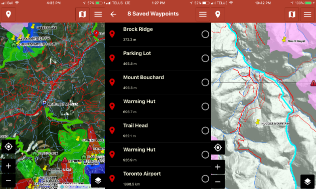
Each year Search and Rescue receives call-outs for missing riders, some who’ve simply become turned around and lost, but others who have become stranded due to dropping into areas they cannot get out of. Bouchard has worked with Search and Rescue to identify and plot these areas of concern to give riders a heads up and the ability to make choices that match their skill set.
Motorized recreation closures and caribou closures are also included on this app, allowing riders to know their current location and precise distance from existing closures. “This is a huge benefit for riders, as much of the feedback I received regarding closures indicates that there is an incredible lack of signage identifying caribou closures, leaving riders unaware they are in a restricted area until it is too late,” he said. With fines and enforcement on the rise, the Never Lost app will facilitate compliance, conservation and stewardship efforts, helping to prevent costly fines and the confiscation of property.
Initially in 2016 and 2017, Bouchard travelled to multiple locations throughout B.C. and Alberta, working with clubs and Search and Rescue organizations to physically map each area. “It was very time consuming and costly to travel to each region, but for me it was a labour of love. I truly believe we will save lives and create a safer sport by providing an easy-to-use and affordable backcountry navigation app,” he said.
New for this year, Bouchard has upgraded and re-released the Never Lost app and is reaching out to a variety of user groups across North America. “I can work with existing clubs and organizations to include their areas on the Never Lost app without having to physically be in their location,” he said. This is a big step for the app, and Bouchard sees endless applications including hiking, mountain biking, fishing and ATVing.
This article originally appeared in the B.C. Snowmobile Federation’s newsletter, Snoscene, mid-winter 2019.
The Never Lost app covers the following areas to date:
Alberta: Alberta Beach, Barrhead, Big Mountain, Edson, Fox Creek, Grande Prairie, Swan Hills, Whitecourt
British Columbia: Blue River, Castlegar, Clearwater, Creston, Crowfoot, Fernie, Gold Rush Trail, Golden, Kakwa Park, McBride, Merritt, Revelstoke, Sea to Sky, Sicamous, Smithers, Tumbler Ridge, Valemount, Vernon/Kelowna/Enderby, Williams Lake
For more info, you can find Never Lost Trails on Facebook.