New technology is officially available at a mountain near you. A new web-based tool and app called the Mountain Information Network was released this season by Avalanche Canada. The app allows snowmobilers and other backcountry users to view local conditions and also post their own observations in real time. This new tool is being used across the country and is improving safety, encouraging local discussions and changing the way we communicate avalanche dangers.
James Floyer is a senior forecaster with Avalanche Canada and has been heavily involved in building the network over the last year.
"It's an improvement on a similar idea which we called the Observer Network that we ran in the 2013/2014 season," said Floyer. "The one main difference is the old system only worked on a smart phone, where with the Mountain Information Network you can input and view observations on your phone and through the website. It's a much more integrated approach, and the technology it's built on is a lot more robust and a lot more stable."
How it works
Avalanche Canada has been wanting to build something like this for years, but projects like this, Floyer said, are very dependent on funding and finding people to implement it. However, the system is now working very well.
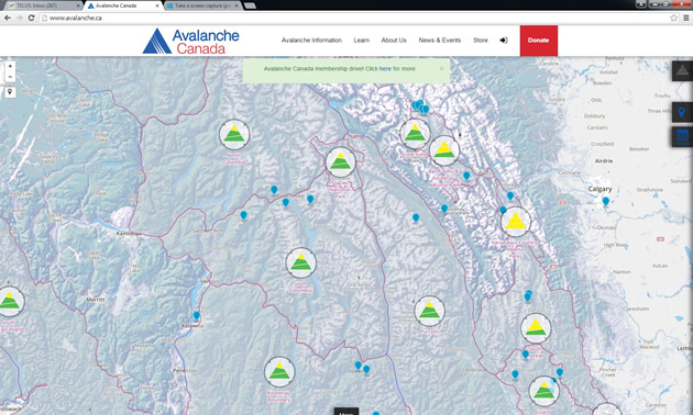
"People are submitting some real high quality information," said Floyer. "There's really three main ways you can make great use of this, with the first one being the trip planning tool."
This tool is for those who are thinking about heading out the next day and who may want to do an assessment of conditions. First look at the public avalanche forecast, which is professionally generated. Floyer recommends then augmenting that with local observations.
"So you might use the tool to do a quick scan around the area you want to ride and see if there's any submissions from the last day or two that may be relevant to that area," Floyer said. "Secondly, if you're out riding and see you something of interest, or you make an avalanche observation, or let's say you find a weak layer in the snowpack, you can share that through the app."
Riders can also simply use the app to take a great photo if they're out having a great day riding in good conditions. It's all very helpful, no matter what people want to share.
Real time media
When you do decide to make an observation or share a photo on your smart phone or iPhone, you can do it right from the mountain, as long as you're in cell range. If you're not, you can cue it up and when you get back into cell range, submit it then. The alternative is to wait until you get back to your computer and submit it via your web browser.
"One of the nice things about the way this system was built is that you can share it through social media," said Floyer. "With the Mountain Information Network, there's no need to submit your findings to multiple different sites. You can share your observations on Twitter, Facebook and other social media sites through the system."
Floyer encourages people to check out the app consider submitting their observations.
"Regardless of weather conditions, stable or unstable, it's all very good information," he said. "In the spirit of giving as well as receiving, the more info we get, the better we can provide information back to people in regards to current avalanche conditions."